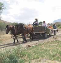
| Wagon rides were part of the fun. |
The 8th annual Cowboy poetry gathering was held on June 1 at the 777 Ranch on Dutch Flat Road in Ferron. This annual event is sponsored by the Baptist church in Emery County. The Circuit Riders a musical group from Cody, Wyo. entertained the large crowd. Also cowboy poet, Ron Ehman from Elko, Nev. recited cowboy poetry.
Parents, children and grandparents alike participated in the hay ride through the fields of the ranch. Young children were also treated to horse rides and instruction on how to handle the horses. A barbeque dinner was prepared and all coming to the event added a dish to the potluck table. Many visitors toured the ranch and inspected the new lodge which is being built.
| Children learned how to ride horses. |
The barbeque was held under the cover of the arena which is being built on the ranch. Pastor Tim Lacock explained the arena was being built as funds become available. “We have three summer camps scheduled for the ranch this summer. These are leadership camps, the campers will have classes, do projects and also learn about horses. We have a duplex on the ranch which can house approximately 22 people. When the new lodge is complete we will be able to have more camps in the summer for more people,” he said.
Area residents seemed to enjoy the night of fun and friends at the ranch.
Increasing fire danger has resulted in a Stage I fire restriction order for most of southern Utah.
The fire restriction took effect on May 24 and it will remain in effect until rescinded.
The Utah Division of Forestry, Fire and State Lands, in conjunction with the USDA Forest Service and Bureau of Land Management have included all federal and state lands in Grand, San Juan, Washington, Kane, Garfield and Iron Counties, and lands west of I-15 in Beaver County.
All lands in Emery and Carbon counties are also included with the exception of National Forest lands in those counties. The order includes Zions, Bryce and Cedar Breaks National Parks, as well as the Moab and Monticello Ranger Districts in the Manti-LaSal National Forest. It does not apply to incorporated cities and towns.
The fire restriction prohibits fireworks, as well as open fires or campfires except in a developed recreation site. Smoking is also prohibited except in an enclosed vehicle or building, a developed recreation site, or in an area that has been cleared of all flammable materials. The use of propane stoves is not prohibited.
“A Stage I fire restriction order is not usually needed until late June or early July, so this is an indication of just how dry things are,” explained State Forester Joel Frandsen. “Needless to say we’re asking everyone to be especially careful with all forms of fire,” he said.
Recreationists are also reminded that if they are responsible for starting a fire they may be held financially liable for the costs associated with putting it out. In even the smallest of wildland fires those costs easily rise into the thousands of dollars.
During the early evening hours of June 10, Utahns will join others across most of North America and be treated to a partial eclipse of the sun, the last to be visible from Utah for 10 years. Times and appearance of the eclipse will vary depending on location but for observers in Utah the eclipse will run from around 6:15 p.m. until just after 8 p.m. Maximum eclipse will occur about 7:15 p.m., when about half of the sun will be covered.
Partial eclipses of the sun occur when part of the moon passes in front of the sun, blocking off part of the sun’s light. “This particular eclipse will be much more visible that the one we had last year,” according to NASA Solar System Ambassador to Utah, Patrick Wiggins.” During that eclipse, Utahns saw only a tiny piece of the sun covered.” “Everyone should be careful not to look directly at the sun during the eclipse or any other time since permanent eye damage may result. It’s also not safe to use items such as polarizing materials, color photographic film, smoked glass, or sunglasses since they do not provide protection from the harmful portions of the sun’s light,” said Wiggins.
Safe, inexpensive solar eclipse filters are available through the mail and from various local retailers. Number14 welders glasses also make a safe yet cheap sun filter. An even less expensive but very safe way to view the eclipse is with a “sunbox” To make a “sunbox,”simply punch a pinhole in one side of an ordinary box and then hold the box so that the sun’s light passes through the pinhole and forms a small image of the sun on the opposite inside wall. “When using a ‘sunbox’ you should only watch the projected image. Do not look through the pinhole at the sun,” warns Wiggins. The next eclipse of the sun to be visible from Utah will not occur until 2012. However, Utahns will see two total eclipses of the moon next year and a third in 2004.
The next total eclipse of the sun visible from North America will not occur until 2017.
The Huntington North Reservoir Resource Management Planning work group met on May 29 at the Huntington North Reservoir.
Chris Sands is the Bio-West, project team leader and their company is assisting the Bureau of Reclamation with the resource management plan.
Sands distributed copies of a proposed fish habitat enhancement project for the reservoir from Louis Berg, regional aquatic program manager. Berg was not present at the meeting. Sands reviewed the document with the group. The proposal describes several phases of improvements to the reservoir with the objective being improved fishing opportunities. Berg points out that in the initial years after the filling of the reservoir it was an outstanding fishery. Shoreline vegetation which provided fish habitat has decomposed and disappeared.
Phase one of the proposed project involves removing the old fish habitat structures, which are tires from the reservoir so that further problems do not occur. These tires in the past have come loose and been sucked into the outlet works.
Phase two of the project would deal with establishing artificial fish habitat structures. The proposed plan would be to dig trenches approximately three feet wide and three feet deep, and 150 feet long. The trench will contain a cabled gang of about 50 fish habitat structures. Each habitat structure will consist of several strands of floating rope attached to a concrete anchor.
Phase three involves placing an oversized marker buoy, connected to a weighted fish habitat structure, at the mouth of the southwest cove area. The buoy will indicate the presence of a fish habitat structure and will state that boats must travel at wakeless speed within 150 feet.
Phase four of the final phase of the project consists of placing 50 fish habitat structures in the deepest portion of the reservoir. Having these types of structures in place in the deepest water will ensure that when the reservoir is drawn down to its lowest levels that the fish will still have appropriate habitat. Monitoring of all phases will be done to check for sedimentation levels and increase of fish populations. Also limited creel surveys to determine angler harvest and catch rates will also be performed during this period. If an improvement in the fish population or in angler catch rates is not documented by 2006, the fish habitat structures installed in phases two, three and four of the project will be removed from the lake by the Utah Division of Wildlife Resources.
Sands pointed out this proposal from Berg is just that, a proposal and the work study group would not approve or deny it; but simply review it and become familiar with it. He said none of Berg’s proposals would be approved until the resource management plan is complete. Tim Wagner from Bio-West pointed out that the resource management plan is more general and that detailed projects come after the resource management plan has been approved.
Jamie Dalton, from the Utah Division of Parks and Recreation said, Berg probably has to plan in advance for funding and needs to begin that process.
Jay Mark Humphrey from the Emery Water Conservancy said they had not been contacted with regards to the fish enhancement project. He pointed out their office would need to approve any projects for the reservoir. He felt Berg was acting prematurely because the resource management plan is not scheduled for completion until summer of 2003. He mentioned phase one of the proposed project has a start date of August-October 2002.
This phase was the removal of the tires. Humphrey explained that the tires need to be removed in a certain way by people who know what they are doing so as not to cause any damage to the reservoir. He stated the water conservancy district could be hired to do the work and he did not see a problem with that.
Humphrey said the public survey part of the resource management plan has not been done yet. The DWR wants a fishery he said, but maybe the public wants boating and recreation. The public has a right here. If the DWR wants to move forward they need to discuss this first with the district and the bureau of reclamation, I think they are moving too fast, said Humphrey.
Dalton, was next with the subcommittee report. He spoke about the southwest cove area and what should happen there.
Ron Taylor, Huntington State Park Manager, mentioned the southwest cove area is under the water conservancy district’s primary area of jurisdiction. If any improvements or changes in status were to take place it would have to be changed to park jurisdiction. Taylor said their only jurisdiction in the cove is limited to law enforcement. Humphrey pointed out for any change in jurisdiction to take place for developed recreation, the park service would have to commit time and resources and do it properly. The water conservancy district could not allow it to be taken over if the money is not there to develop it properly.
Sands added that yes, it would take considerable money to develop facilities in the cove. Current access to the cove will be maintained. It was determined that it is a county road leading to the cove, but it is in poor condition. Humphrey pointed out the need for some access areas to remain fee free.
Dalton pointed out the need to formally adopt a boating limit. “Ron Taylor, Tim Smith and I will look at a draft policy,” he said.
Wagner was next with his report. He said they have been pulling together baseline data to serve as a foundation for the resource management plan. He said they will look at different alternatives and management strategies. He said they have gathered a brief history of the county and statistics on the reservoir. He gave a brief description of the climate and the air quality of the reservoir. He listed shoreline erosion as a problem, it is due to wave action and fluctuations in water levels. They are identifying areas around the reservoir which are most susceptible to erosion. There are no shallow ground water hazards in the area, with the ground water 30 feet below the surface.
There are some seeps south of the dam which have contributed to a wetland area. The soil is a clay loam and soil erosion is not a big issue. Wagner mentioned that by law, threatened or endangered species within the project area have to be identified. He said there are some occasional sightings of bald eagles and peregrine falcons. Birds are the most consistent form of wildlife at the reservoir.
The only historical value of the project area was identified as the old Mohrland ditch which was built between 1898-1907 and served five families in the area. It was abandoned in 1962-63. Fossils have been identified in the area. No Indian trustland has been identified. The recreation and visual qualities of the reservoir include fishing, camping and water based activities such as swimming and boating. The reservoir has been divided into five major use areas: the dam, the state park, the northern section, the inlet and the southwest cove.
A history of the usage of the reservoir was also discussed. In 1992, 85,743 visitors were recorded. In 1995, 58,264 visitors. Taylor said a good average is 60,000 visitors per year. Bio-West has also been identifying any records to find management agreements and permits and anything that could have an effect on management. They have found that Utah Power has an easement for right of way for a power line. They have identified six other permits like the one with Utah Power.
The existing management will be part of the phase one document. A visitor survey has been started at the park and will continue through Labor Day. This survey will help to detail desired recreational interests at the reservoir.
Jim Jensen, reclamation team leader, said that the contracts for the management of the 11 reservoirs by the state parks is in the renewal process and they will be finalizing the state park agreement. They are trying to lump these reservoirs together under one contract.
It was pointed out that NEPA requires a wide range of alternatives that spell out land use in all categories. Sands said they will be putting ideas down to react to. There are no specific alternatives yet. Peter Crookston, from the bureau of reclamation mentioned that when looking at alternatives things go from one extreme to the other and things usually fall into place somewhere in the middle.
Sands said at the next meeting the phase one document will be distributed and the alternatives will be refined. The next work group meeting will be held in July. This will give the necessary time for the draft document to be completed.
Construction work in the Castle Valley area will continue in the weeks and months ahead. On SR-6 in Spanish Fork Canyon road work will continue for the week of June 3. Roadway excavation will continue on the north side of the highway from mileposts 196 to 200. Excavation and grading operations are currently day shift only Monday through Saturday. Maintenance operations will be performed throughout the night. Flaggers will be stopping traffic intermittently throughout the week. Expect delays of five-15 minutes when flaggers are present. A concrete barrier has been placed along portions of the project from mile post 196 to 200 narrowing the highway. Any oversized load or wideload concerns should be directed to the port of entry. The speed in the construction zone is 45 mph. Please drive carefully and be prepared to stop.
Fishing waters throughout Utah should see plenty of anglers June 8, as the Division of Wildlife Resources marks Free Fishing Day in Utah.
People will not need a fishing license to fish in the state that day. All other regulations found in the 2002 Utah Fishing Proclamation will be in effect.
“We’re trying to attract people to fishing by having a free day,” says Tom Pettengill, sport fisheries coordinator for the Division of Wildlife Resources.
Division staff treat Free Fishing Day as they would a holiday weekend, stocking additional fish to meet the additional demand. Pettengill says anglers fishing June 8 may want to focus their efforts on lakes and reservoirs, as this is where most of the fish stocked for Free Fishing Day will be placed.
Pettengill reminds those fishing June 8 that while no license is required, all other limits and regulations found in the 2002 Utah Fishing Proclamation will be in effect. Anglers, especially those who might be fishing for the first time, are encouraged to pick up a copy of the proclamation and learn the rules.
Proclamations are available from fishing license agents statewide; at Division of Wildlife Resources offices in Ogden, Salt Lake City, Springville, Vernal, Price and Cedar City; and on the Division’s Web site (www.wildlife.utah.gov).