| The group also looked off the Wedge as part of the BLM tour of the Swell. |
On the morning of Oct. 12, the group met at the Museum of the San Rafael at 10 a.m. for a day of Paleontology/Archeology/Geology by tour guides from the Bureau of Land Management. BLM geologist, Mike Leschin and archeologist, Julie McGhee were the guides for the San Rafael Swell tour that Saturday morning.
Leschin greeted everyone with a hearty “Do you have a full tank of gas?” Upon hearing this participants knew they were in for a full day’s adventure. Fifteen people, including two guides, left the museum in eight cars.
People came from all over the state to see the Swell. A retired couple from Odgen, two gentlemen from Payson, two women from Price, a woman from Ferron, who has just recently relocated from Boston and her two boys, three Emery County residents, two tour guides and a tour guide’s husband had assembled for the day’s tour. The first stop was to regroup at the desert turnoff on Highway 10.
Then the adventure began. After traveling into the desert for several miles, the tour again stopped and Leschin pointed out that they were standing in the Mancos Shale formation. He explained the anticline known as “The Swell” stretches 65 miles from north to south and 40 miles from east to west and is on the western edge of the Colorado Plateau. Elevation ranges between 4000 and 7000 feet.
Leschin explained that the whole area was once under water and that water was fresh water not salt water. Although he said the ocean was not to distant to the west.
On the way to the Wedge they passed through at least six different formations including, the Mancos, Dakota, Cedar Mountain, Morrison (which is the biggest source of dinosaur bones), Curtis and Carmel. At an abandoned gypsum mine, they learned there are three types of gypsum, selenite, alabaster and satin spar. After a little exploration of this mine the group continued to the wedge.
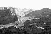
At the wedge, Leschin pointed out the other formations exposed in the depths of the canyon known as “The Wedge.” He named them off, the Navajo, the Cayenta, the Wingate and the Chinle, explaining the characteristics of each formation.
Continuing on into Buckhorn Draw, they stopped at the Buckhorn and Cattle Guard panels of pictographs. Julie McGhee, the tour’s archeologist explained to the group how the panel was restored.
She also told some history of the panel and its significance to the archeological world as she called them “a non-renewable resource.”
| Visitors observe the rock formations. |
The final stop of the day was at the Cleveland-Lloyd Dinosaur Quarry. Leschin explained that the deposit of bones found there are the largest concentration of dinosaur bones found anywhere. Scientists are still trying to discover why the concentration is so dense. An interesting tid-bit was that of all the bones found in this quarry, only one dinosaur egg has been uncovered.
Leschin said two-thirds of the bones found there are those of the Allosaurs and bones from this site have been distributed to at least 65 museums around the world. He stated that tests of the area have revealed the bone layer to be three feet thick and is less that an acre is size.
The quarry site underwent some major improvements in 2001 on National Public Lands Day. New concrete sidewalks were installed, landscaping work done and fencing work to restrict the use of ATVs to prevent any damage to the quarry.
Tours have also been conducted to various other areas throughout the Swell led by various experts in the science fields.