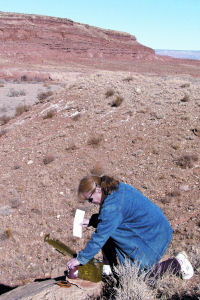
| Geocacher Marie Lindquist opens the Red Ledges cache which contains a bracelet, fortune cookie, shot glass, quarter and other items. |
Emery County is a great location for the current worldwide outdoor recreation boom, Geocaching. This is a treasure hunting game that all ages can enjoy. Geocaching can be done at any time during the year, providing access is available.
To participate, a person must have a GPS (a handheld global positioning system). This device reads information from satellites and determines the location in relation to the longitude and latitude numbers on the Earth, and transmits those coordinates to the GPS readout. These coordinates are used to navigate around the surface of the Earth and locate specific points.
Geocaching enthusiasts hide caches, usually on public lands and usually in ammo boxes or PVC tubes, and also range from Tupperware bowls to ice cream buckets. Inside the cache is a log book for those who locate the cache to sign and date, along with little treasures. These treasures include key chains, toy cars, jewelry, stickers, pins, or virtually any small trinket that is not harmful or dangerous. A cache seeker carries little items with them, and when a cache is located, the finder has the option to leave an item and take an item, which is then noted in the log book when it is signed.
| The treasures from the Red Ledges cache are in an old ammo box. You can pick a treasure and leave a treasure. |
Some caches around Utah are virtual caches, such as a historic building or well known landmark. Geocaching is a great way to get to know Utah, and then expand to see the rest of the country as this hobby is practiced around the country as well as the world.
On the worldwide web there are sites dedicated to geocaching. They require a person to register a user name and password, but it is a free service. Once logged in, a user can request a search of all the registered caches within a certain mile radius of his home coordinates. Within a 50 mile radius of Castle Dale, the geocaching.com website lists nearly 460 caches waiting to be discovered.
The first site visited in making this story was the Red Ledges cache, a traditional cache, by DeViDe. It’s coordinates are N 39 degrees 02.248, W 110 degrees 56.763. The second was near Castle Dale called the Oreo Cookie cache by mtwilli. It is a traditional cache with the coordinates of N 39 degrees 12.230, W 111 degrees 00.620.
This activity provides outdoor experiences and an avenue to meet other enthusiasts and compare treasures. Geocaching is not a way to become rich with treasure, but rich with the experiences that the outdoors in Emery County and Utah, can provide. Watch for upcoming geocaching events at the Emery County Fair and in Goblin Valley State Park.