| A technical workshp held in Price on Aug. 28 was part of the process to gather information on the resources within the San Rafael Swell. |
A technical workshop was held at the College of Eastern Utah Prehistoric Museum on Aug. 28 in Price.
The workshop was held as a starting point in fulfilling the request to the Department of the Interior by President George W. Bush to, “Please provide me any information available to your department on lands owned or controlled by the United States in the general area of the San Rafael Swell that contain historic landmarks, historic or prehistoric structures, or other objects of historic or scientific interest.”
A welcome was given by Tom Rasmussen from the Price Field Office of the Bureau of Land Management. The BLM has contracted with Booz, Allen and Hamilton to gather the information for the resource inventory. Emery County Commissioner Randy Johnson was introduced to the meeting and spoke next, “Emery County has been involved for a long time planning for the county and discussing what ought to be done. Ninety percent of the county is federal and state land. We need to do something to be good partners. The area is gaining national interest. I took a friend down for a short trip to the Swell and we passed cars from six different states while we were there. It is of interest and it draws stakeholders whose values and opinions disagree. We’ve had trouble passing any legislation to protect the Swell. It is a pleasure to be part of a precedence setting partnership to gather input for the President. We hope the process we are now in the middle of will provide trend setting in public lands issues.”
Wes Curtis from the Governor’s Rural Partnership spoke next saying that things are different up front with this idea for a monument proposal simply because, “We are having a process, we are doing this as a partnership. It is not the feds, not the BLM, not the county, not the state; but a partnership. We are involved in something historic. What we’re doing has the attention of the governor, president and the nation as a whole. This is a high priority for the governor and we appreciate
the opportunity to be partners.”
Gary Armstrong from Booz, Allen and Hamilton was the facilitator for the workshop. He said the need for there to be adequate acreage to protect the resource will be addressed in the research document; the what and where to preserve and enhance resources. The resource inventory process is monument neutral and will just portray the resources as accurately as possible. He described the San Rafael Study process and how they will go about it. On Sept. 19 and 20 at the Emery High School there will be a resource forum which will be comprised of a general session and breakout sessions to discuss various aspects of the Swell. Some of these sessions will be conducted by local people and those with expert knowledge in their particular field.
Armstrong said, “This will be a two day learning experience to learn about the Swell from those who know the resources already. We will involve the high school kids because they are our future and we will draw from their ideas as well. There will be a dinner break and then an evening session. Everyone is invited. There will be a short video on the Swell and also panel discussions where the public can ask questions.
“In the resource inventory report which will be sent to President Bush, there will be 10 chapters with eight to10 pages discussing the subject areas. There will be maps that identify the resources. We will also be conducting tours of high interest areas such as the Buckhorn Panel and others. The area tours will begin on Sept. 21 the day after the forum. We want to get people out of the classroom and have them see some of the areas first hand, the archeological sites, the dinosaur quarry and we hope to have a description of what is at that particular site by a professional who can share their expertise. These tours will be conducted on Saturdays throughout October.
“The next step will be the public meetings where people can come and learn. They will be held in Salt Lake, Castle Dale, Price and Green River. They will operate on a three stage format. They will begin at 4:30 p.m. with an open house. There will be descriptions and maps of the 10 subject areas. There will be a dinner break and then a presentation of the process afterwhich there will be breakout sessions to discuss what’s important to the citizen. All material will be recorded and the feedback included in the report that goes back to the president.
“The website will constantly be updating information on the process with items of interest. ut.blm.gov will take you to the site where you click on the Swell specifically. The survey being conducted by Dr. Keith Allred will bring interest groups together to help formulate questions. Someone in Emery County will have a different view than someone in Florida who has never been here and the survey is an opportunity for the sharing of different views. The survey will also be available on the web.
“At this technical workshop today we will assist in the development of a resource inventory which we will share at the resource forum in Castle Dale. What do you know about the Swell? What is your expertise? What are the grazing impacts, socio-economic impacts; what about ecology? We will share data and help shape the tour concepts as well,” said Armstrong.
The question was asked about the borders for the monument proposal and if the areas of concern needed to stick to the confines of this border. Armstrong explained that the borders are fuzzy and that the uniqueness of the Swell and all the different resources and histories cannot be confined, but the directions of the president concerned those resources in the San Rafael Swell area.
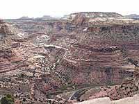
It was pointed out by Jim Kirkland from the Utah Geological Survey they have a map which they made for the school trustlands land exchange which would be helpful in this information gathering process. He said the San Rafael is a double plunging anti-cline which is unique. It contains a remarkable record of the end of the Cretaceous period. He also pointed out that not many studies have been done on the Chinle formations. He also pointed out that petrified logs and small marine fossils are found in the area. Some small bones have been stolen from areas, but most of these sites lie in rugged country. “Closing the roads is the worst thing you can do to a paleontologist. Utah has one of the best records on the planet. We don’t know what’s in there (Swell) and we don’t want to lose access. It doesn’t exist unless scientists can get to it to work on it,” said Kirkland.
He also mentioned that Oklahoma State had done excavations on sites in the Cedar Mountain and Morrison formations and removed 80 tons of material to take back to study. They are finding one mammal per one ton of material. “We have world class paleo resources. The blending of paleo/scientific research is a modern use of the Swell,” Kirkland said.
Each of the 10 areas identified as resources for inventory were listed on large sheets of paper at the front of the room and were then filled with the ideas of participants. These areas are: paleontological resources, archaeological resources, geologic resources, ecology and life zones, flora and fauna, history of presettlement-Native American, history of outlaws and pioneers, mining history, pioneer and ranching heritage, modern uses and human involvement.
It was pointed out that the topographical upheaval of the Swell was used as the boundary when the area on the map was outlined as the proposed boundary for a future monument.
Armstrong also mentioned the access to the paleo sites would be something included in a monument management plan. It was also mentioned that the resource management plan is underway at the Price BLM field office regardless of a monument designation or not.
| Mark H. Williams and Paul Crawford talk about the San Rafael during the workshop. |
Don Burge, CEU Museum director, mentioned that he had been on the Morrison and Cedar Mountain formation doing research for 40 years and security is always a big issue. He said some of the dinosaur bones are really big weighing in excess of 2,000 pounds and that access is a problem in trying to get the bones out.
Locating information on the I-70 construction dissecting the Swell was mentioned as a good resource for information on rock shelters. Paleo and botany research was done as part of the I-70 construction and that data could be used in the report.
Tour guides were named to help with the part of the tours dealing with the paleontological resources of the Swell; John Bird, Don Burge, Ramal Jones were all named to lead these tours. Mike Leschin will be available at the Cleveland-Lloyd dinosaur quarry to visit with the tour when they visit the quarry.
It was mentioned that as these repositories are explored it would create a boon for Burge and the CEU Museum as well as other museums in the two county area. Jones also mentioned that when excavations occur locally that our local museums be considered to receive some of these materials.
Travel guides that have been written and unpublished works concerning activities on the Swell will all be included in the work. BLM has done some work noting sites where Indian writing occurs and Margaret Fugate-Swasey noted that there are 300 recorded sites of writing within the county. It was also mentioned there are probably thousands of sites which are not documented.
Armstrong said the inventory will be of the resources that we know of. It was also mentioned that the state history department also has information available.
Audience members noted worthy resources of activities that went on in the Swell including the Old Spanish Trail, history of the railroad, important archeological sites including the Rochester and Ferron Box areas. Traditional and Native American uses will also be included. It was mentioned that Doc. Dorman was an expert on these sites and that although he has passed away his literature and writings concerning the Fremont Indians and other topics should be included as a resource.
Burge mentioned that the CEU Museum itself should be included as a resource. It has 650,000 catalogued items and is a research center; some of Doc. Dorman’s works are also archived at the museum. It was mentioned that native tribes be contacted to see what information they can provide on their history. The human involvement in the Swell was mentioned and Burge pointed out the extensive cowboy/outlaw history of the area with Butch Cassidy and the Hole in the Rock gang and others. Old historic cabins and remnants of that era are rich in the Swell. Swasey’s Cabin is also part of that history. The uranium mines, MK tunnels, Copper Globe, oil drilling operations, vanadium mining were all mentioned as parts to be included in the report.
Jones mentioned that when the Emery County Progress newspaper was established in 1900 there were a number of articles pertaining to mining history and the various mining operations and those could be used as a resource. Owen McClenahan also wrote about prospecting on the Swell and Mark H. Williams has published a guidebook on the Swell and its attractions. These works should also be included as resource tools.
Jeep tours and ATV tours were also mentioned and guides to lead visitors to resources. Montell Seely, Ed Geary, Vernell Rowley, Joel Frandsen, Wes Curtis were among the names mentioned as tour guides and resources on mining history, settlement history and folklore unique to the region.
Dickson Huntington also said that along with the ranching heritage is the modern day grazers and information about those uses can be obtained from the Utah State Extension office. He also said the Swell contains at the present time 60 permittees, 37 allotments and 26,000 AUMs.
Jeff Durrant from the geography department at Brigham Young University said he and his students have conducted research on the grazers and their allotments and interviewed numerous ranchers. They have also compiled maps outlining allotments, where water sources are and other valuable information concerning grazing on the Swell.
Wild burro and horse history should also be included in the report. There are eight endangered species on the Swell and 17-18 sensitive species whose information should be included.
Human uses for recreation included: Easter on the Swell: An activity unique to the region, when thousands of people converge on the Swell and camp in dispersed areas and eat, drink, roll Easter Eggs, ride ATVs and create dust for the entire Easter weekend. Hiking, camping, rafting, rock climbing, mountain biking, rockhounding, scientific tours, trail rides, solitude seeking, hunting, ATV uses, backpacking, day packing and getting lost were all mentioned as human activities on the Swell.
It was pointed out that geologists from around the world will converge on Price in the fall and attend a series of geology field camps to be held in the Swell. Information on the animal activities in the Swell can be obtained through the Utah Division of Wildlife Resources.
Mark H. Williams and Brian Hawthorne volunteered to help with the recreational tours to the Swell. It was mentioned that the I-70 construction in and of itself is important Swell history. The history of the Bighorn Sheep was also listed as an important part of Swell history; the original sheep herds as well as the work done to reintroduce them to the area. Utilities and communications paths and their part and history will also be included. Geological markers, grave markers and historic headstones were also noted.
Brian Hawthorne mentioned that in going over the GSENM management plan information included could be describing three quarters of the state and in regards to the Swell he wondered what made the Swell so special to warrant monument status.
One answer came back that the Swell is the only place on the planet for some of these formations and without access you can’t do the scientific research. In his experience he said he has had easier access in national parks for his research than in any other place.
Dick Manus retired Price Field office manager is taking the lead with the tours and coordinating them. He said they will all begin at a central location, probably the museum in Castle Dale. A power point presentation will be conducted in house before the tour and then the field trip. They will have a reservation -RSVP system and any number of people can take the tours. They will use their own personal vehicle. These tours will be advertised on the website and also at the research forum.
Manus also mentioned the meetings in Castle Dale as being for the people to learn and absorb with information going out and question and answer sessions with the experts. “These meetings are not to rationalize a monument as was done after the creation of the GSENM, this is not to promote or deny but to educate the people on the scientific resources of the Swell.