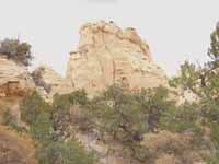
After the recent election when Emery County voters placed their votes against the beginning of a monument proposal for the San Rafael Swell, management will continue under the Bureau of Land Management’s resource management plan. This plan is currently in the stages of being rewritten and revisions added to the existing plan.
Floyd Johnson from the Price Field Office of the BLM said, “The Price River District and the San Rafael district will be combined into one in the new RMP. This will be much easier and will just contain one set of requirements instead of the two we are now working under with the two districts. In the Emery and Carbon county area the BLM manages 2.5 million acres of public land. They also manage 2.8 million acres of mineral rights; these mineral rights cover places where the BLM owns the minerals and also areas which include private and forest land. The BLM deals with those who want to explore and develop minerals on the BLM lands as well as those who want to develop private land, these all fall within the BLMs jurisdiction. We deal with where to lease coal, oil and gas and we determine what if any sand and gravel operations or clay and gypsum permits will be allotted.
“The RMP deals with a number of things, grazing is a big issue right now as well as OHV use and other recreation uses. We will address camping and determine where it can take place. We will also address where to establish mountain bike trails and horse trails. The Division of Wildlife Resources manages the animals and the BLM and the forest service manage the habitat for those animals. The areas within the RMP contain critical range for wildlife and it must be managed to protect that value. We will also look at threatened and endangered species, plants, animals, vertibrates and fish; we will look at land tenure where right of ways exists for corridors for utilities. We will look at areas where the BLM might dispose of land and areas where we might acquire land. We will look at areas where we might allow cities to acquire BLM land where there is a public need.
“We will look at river management and the Green River will be discussed. We will look at the wilderness study areas. We will look at areas of BLM land which display wilderness characteristics. We will look at areas which deserve cultural protection areas such as the Buckhorn Panel and the Rochester Panel as well as many others. We will look at paleontological resources and the management of the Cleveland-Lloyd dinosaur quarry. We will look at fire management within the area and develop zones and areas where we would need to put out a fire and areas which we would let burn that weren’t effecting anything. Fire can be a beneficial device.
“We will also be addressing air and water quality and wild and scenic rivers. There has been a lot of discussion on the wild and scenic rivers lately. There will also be different classes of visual resource management to maintain visual resources.
“We will also look at areas where we would allow wood gathering to take place and areas where we wouldn’t.
“All of these different areas and more will be folded into a comprehensive plan. People need to realize that not all uses will be allowed in all areas. The BLM will determine where certain activities are authorized and where they are not.
“The notice of the beginning of the RMP process was placed on the federal register in Nov. 2001. In December of 2001 we put out the planning bulletin one and the public meetings were held in Jan. 2002. The comment period where the public could respond with their issues and concerns resulted in a total of 11,000 comments; 9,800 of which said to accept the Red Rock Wilderness proposal. We looked at each piece individually and looked, gleaned and reviewed them. These were included in the scoping report and are also on the website. The RMP is being completed in a number of portions. The first part is the synthesis of the information. The next part will include public meetings where we will identify major issues and concerns and they will be addressed. It is impossible to address all issues, but it sets up a spectrum. We will deal with comments that say in the case of OHV use, to leave everything open and some that will say to close everything. We deal with a full range of comments and it is our responsibility to achieve balance in dealing with these issues.
“We go for in the planning development and establish alternatives. These alternatives will encompass all of the spectrum to a reasonable degree. A scoping report has been prepared for each of the resource areas and the comments will help to guide us as we move into planning. We are nearing completion of the mineral potential report and it is on the website but isn’t fully completed. We are still working on the coal section which will be added to the report.
“What we are doing is taking an inventory to know where the minerals are and this will play out as we move forward with the alternatives. It could ultimately mean that more than one use is feasible in different areas and an area wouldn’t specifically be set aside for mineral exploration at the expense of other uses. The BLM works to decide and pinpoint higher uses of the lands and places where multiple use of an area of land can be adapted. We will receive public input on these sorts of decisions, but we aren’t there yet in the planning process.
“We have requested an extension to the department of the interior for the RMP process but we don’t know yet if it will be granted. We will continue to move forward. We are involved in ongoing efforts which are not complete yet like the baseline socio-economic study and air quality study. We have contracted with Booz, Allen and Hamilton to help on these studies. They wrote the minerals report and have been going through and identifying comments. We have augmented our mailing list and added the names of all those who have commented in the process. The names have been added to the data base. They have also been working on the socio-economic study and have been in contact with both counties. They have a draft copy of an air quality report prepared. They have been helpful in doing a lot of the leg work for the RMP process.
“The travel plan will be folded into the RMP. We will have a final travel plan in January or February of 2003. The BLM developed four alternatives which ranged from keeping everything open to alternative three which was the most restrictive. The process of closing roads was based on a set of criteria. We are closing roads with conflicts such as threatened and endangered species and some are based upon threatened riparian zones. We received comments on the travel plan and the substance of each comment was analyzed. We received comments about routes which weren’t on the map and these have been added to the map. Also there were places that routes didn’t exist which have been adjusted. Some people have said to close a route and then listed their reasons. We will look at their reasoning and see if this reason will change our position on the route.
“People who have listed a reason as, ‘it is a beautiful place to ride,’ with no data; then we can’t react to comments like that. Also people who have said to close everything, we can’t adjust to comments like that. We’re analyzing data in that process now. The preferred BLM alternative was number four and we are leaning toward alternative four without major provisions either way. The numbers have probably shifted a little, but alternative four leaves 700 miles of road open and the base is slightly under 1,100 miles of road. The RS-2477 road issue is still being decided and that will take precedence over our travel plan if they determine a route is to be left open that is not on our plan. We have had a RMP on the Swell dealing with OHV use restricted to designated routes since 1991, people have ignored this travel plan. No OHV use was allowed on any roadway that didn’t already exist. We will be closing routes that are user created. We have sustained a lot of damage to the resource and will be more restrictive to protect the resource, but there is an awful lot still left open.
“Routes are looked at in zones and in certain zones problems exist such as threatened and endangered species and those routes are likely to be closed and also routes that don’t go anywhere and don’t accomplish anything; it doesn’t make sense to keep them open. We will rehabilitate roads as funds allow to discourage the temptation for riders to use them.
“The OHV groups have been very helpful in trail work and we have plans to use volunteers for maintenance projects. We would also like to encourage the environmental community to get involved in some of these projects as well as the BLM public lands day which targets an area for improvement each year. Education is vital to let the OHV community know which routes are open and which are not. Riders can educate other riders and that is vital. We need a good map which designates the routes for people to go. Signs are also a big help which indicate no vehicles beyond a certain point,” said Johnson. The Swell will continue to be in the forefront of discussion in the county and with others who are interested in its future.
(The Emery County Progress will continue the discussion of the BLM and the Swell in future issues)
What’s Next for the Swell?