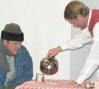
| Pastor Tim Lacock plays Anton who gives a warm drink to the street sweeper played by Tom Bell. |
The First Baptist Church in Ferron presented a Christmas play entitled “Anton’s Christmas Visitor.” Members of the congregation played the parts and Pastor Tim Lacock played Anton. The story begins with Anton, a very depressed cobbler, during his first Christmas following the death of his wife and daughter.
Anton hears Jesus’ voice with a promise of a Christmas visit. He readies himself and his home for the special Christmas visitor. On Christmas morning he begins his anxious waiting.
During the wait, Anton hears a lonely, cold street sweeper in the street. He welcomes the man into his home for something warm to drink. Later in the day, Anton hears a widow woman and her child. He also brings them into his home for warmth and gives the baby a toy.
Another ruckus Anton hears is a street urchin stealing an apple from an apple seller. Anton stops the theft and pays for the apple so the urchin can have something to eat. When two beggars stroll by, Anton gives them coins from his purse.
At the end of the day, Anton is very disheartened because Jesus did not stop by and he goes to bed feeling very depressed again. During the night, he hears the voice again and Anton complains of the missed visit. Jesus explains that he visited with Anton four times during the day and each time Anton was welcoming and helpful.
Following the presentation of the play, the choirs from the congregation sang several Christmas carols, carols, and a cookie fellowship followed to complete the evening of Christmas celebration. Anton even though he did not meet Jesus face to face was able to show the love of Jesus to those he welcomed into his home. It is through others that Jesus meets the needs of the people on earth. Anton’s message seems to be to help those we meet along the way, without thought to ourselves. Through good deeds and service we can all become an Anton who answers the call to serve others in small ways.
| Concerns about coal mining too near Joe’s Valley Reservoir dam led to a 1.8 mile buffer zone for the Cottonwood tract lease. |
John Blake from the School Institutional Trust Lands Administration reported to the Emery County Commissioners the bids for the coal lease of the Cottonwood tract will be opened on Dec. 31. The bids closed on Dec. 28. Blake explained in 1998 there was a land exchange to trade out the SITLA lands within the Grand Staircase Escalante Monument Kaparowitz Plateau. SITLA acquired land above Joe’s Valley from Trail Mountain to the south. There are two parcels being leased, parcel one is the Cottonwood coal exchange tract which includes 8,203.87 acres. The second parcel is just SITLA land which is 600 acres. After the coal has been extracted from the land exchange, that land will revert back to federal ownership.
This combined acreage is estimated to hold 48.5 million tons of coal. “We are interested in having this coal leased and mined. It is being advertised and the bids will close on Dec. 28. We have had a lot of interest in this tract. Hopefully we’ll have some bidders. We will get it leased after the first of the year. Hopefully in the next few years it will get going,” said Blake.
There is a small triangle of land not included in the lease. Geological information indicated it didn’t look recoverable. The border of the lease runs right up to where the Trail Mountain mine was at when they closed.
It is estimated the cover for any coal recovery in this lease area will have an overburden of 2,600 feet. Trail Mountain had an overburden of 2,200 feet in the last section which was mined there before they closed.
One important point Blake stressed was the buffer zone between Joe’s Valley dam and any mining activity. This buffer zone will be 1.8 miles. This is the same distance that was used before when Trail Mountain was active.
Commissioner Gary Kofford spoke in favor of the sale of the coal tract.
After the commission meeting Blake and SITLA Assistant Director of Minerals, Thomas Faddies, met in another meeting to further discuss the lease of the Cottonwood tract.
Blake began with an explanation of SITLA and how it operates. He said it is their job to manage the lands Congress granted to the State of Utah and to do so with financial responsibility as their primary importance. SITLA is managed by a seven member board and Kevin Carter is the head of the administration. SITLA lands comprise 3.5 million acres in Utah. One million of these acres have mineral interests.
Blake explained with the Cottonwood tract, SITLA only owns the mineral rights and not the surface lands. After $13 million in royalties plus interest are realized from the Cottonwood tract it will revert back to federal ownership. The Bureau of Land Management has been very active in an advisory role as this tract was readied for bid. Steve Rigby with the BLM has done a lot of work and consultations with SITLA on the matter.
SITLA said they have held the tract off the market until enough interest was expressed on the coal lease. They have that interest now and the industry seems ready.
SITLA has done a lot of work defining the boundaries of the tract. The whole tract is not up for lease, because of the 1.8 mile buffer zone near the Joe’s Valley dam. This area which will not be used for mining contains a coal block of 1,400 acres.
The reason two parcels are being listed is because the school section will remain SITLA land even after it is mined out. There were also some stipulations on the exchange land requested by the United States Forest Service which included preserving other resources. The two separate parcels will only have one bid which covers both parcels. The tract is bid at cents per ton. Faddies said the tract will go for a considerable amount of money. The bid is based on the estimated 48.5 million ton of coal within the 8,803.87 acre area.
Those at the special meeting included representatives from the Emery Water Conservancy District. They have been working with SITLA for several months with input on the buffer zone for Joe’s Valley Reservoir. Scott Martin, counsel for the district from Snow, Christensen and Martineau said they have enjoyed the courtesy of SITLA and the open communication with respect to the dam concerns. The district understands the importance of the coal lease and supports SITLA in this process. The district supports the lease and its current 1.8 mile buffer zone around the dam. Martin said they would appreciate correspondence and notification should anything change regarding the lease.
Craig Johansen from the EWCD board said it is important to note the 1.8 mile buffer zone is not an arbitrary number. The Bureau of Reclamation has done seismic studies in regards to dam safety and three major studies on the issues surrounding the Joe’s Valley Dam. The 1.8 mile buffer zone was reached by a scientific and practical method.
Blake also added that SITLA has done studies of its own regarding the affects of seismic activity on the Joe’s Valley dam. “The 1.8 mile buffer zone is what it was mined to before and we wouldn’t want to go any closer without additional information,” said Blake.
Johansen said the district is satisfied with the work of SITLA in regards to its proximity to the Joe’s Valley dam.
The Emery County Progress has come a long way over the years. The paper came into existence in 1900. Here is an excerpt from the Sept. 15, 1900 issue:
“The publishers of The Progress have purchased from Mr. C. A. Hyde the printing material, presses and plant of the late Emery County Record, and perhaps with our next issue, at any rate not later than the first of October, will print The Progress at Castle Dale.
“It will take a week or 10 days to get the plant cleaned up and in shape to get out a paper. It is expected to have a man here in charge of the plant within the next few days, but it may be a week or 10 days.
“After the first of October we shall be prepared to do job work of all kinds, and solicit the patronage of all.”
In 1957, the Progress merged with the Green River Leader to become the Emery County Progress-Leader. In 1977 the name was changed back to the Emery County Progress.
Recently the Emery County Progress staff along with management from the Sun Advocate newspaper toured the plant in Richfield where the local newspapers are printed. Mark Fuellenbach is the publisher for the Richfield Reaper and he was the tour guide explaining how the printing presses work. The printing process goes through 60 rolls of paper each month for all the publications printed in Richfield. From each roll of paper approximately 15,000 to 18,000 newspapers can be printed. He explained that each of the rolls are extremely heavy and are moved with a small loader as each roll weighs nearly 1,000 pounds.
The Progress is sent electronically to the Richfield office by 5 p.m. each Monday evening.
The papers are printed throughout the night and the driver picks them up in Richfield each week and transports them back to Emery County. The inserts are placed in the newspaper at the Price office and the courier distributes the papers to the stores and post offices each Tuesday afternoon.
The paper is on the stands by approximately 3 p.m. and the post offices get the papers into the boxes on Tuesday afternoons.
The only changes to these printing schedules occur around the holidays when the papers are sometimes printed earlier than usual. With the Christmas paper, it was printed on the Friday before Christmas, Dec. 21 and then delivered to the stores and post offices on Christmas Eve.
The New Year’s Day paper which you are reading now, was printed on Friday, Dec. 28. The staff at the Emery County Progress look forward to bringing the county residents the news and events of 2008.
The six National Forests, Ashley, Dixie, Fishlake, Manti-La Sal, Wasatch Cache, and Uinta in Utah have released a Draft Environmental Impact Statement (DEIS) for Wild and Scenic Rivers Suitability. The DEIS will be available online at http://www.fs.fed.us/r4/rivers/. Hard copies can also be viewed at local Forest Service Supervisors offices throughout the State of Utah and at major public libraries. The Forest Service will receive public comments on the DEIS through Feb. 15. Comments may be submitted by Mail: Utah NF Wild and Scenic River DEIS, P.O. Box 162969, Sacramento, CA 95816-2969; E-mail: utahnfwsdeis@fscomments.org; FAX: 916-456-6724.
“Publishing the Suitability DEIS represents an important milestone for Wild and Scenic Rivers on national forest system lands in Utah,” said Cathy Kahlow, Forest Service Team Leader.
“Of the many rivers segments we are studying we have some outstanding candidates. We hope that the people of Utah will continue to be involved in this study to determine which rivers in Utah should be selected for inclusion in the National Wild and Scenic River System.”
The draft identifies a preliminary recommendation of which segments should be included in the Wild and Scenic River system. The final recommendation which is expected late 2008, is a preliminary administrative recommendation that will receive further review and possible modification by the Chief of the Forest Service, Secretary of Agriculture, and the President of the United States. �The Congress has reserved the authority to make final decisions on designation of rivers as part of the National Wild and Scenic River System.
Public Meeting Schedule
During the months of January and February, the Forest Service will host several public meetings throughout the State to educate the public about this important effort and to receive comments on the DEIS. Public meetings will be held from 7-8:30 p.m. (7-7:30 p.m. formal presentation, 7:30-8:30 p.m. informal open house) on the following dates and in the following locations: Jan. 8, Provo, – Courtyard Marriott, 1600 North Freedom Blvd.; Jan. 9, Escalante, – Interagency Visitor’s Center, 755 West Main Street; Jan. 10, St. George – Dixie Center, 1835 Convention Center Drive; Jan. 17, Richfield – Snow College – Richfield, 800 West 200 South; Jan. 22, Monticello – San Juan County Courthouse, 117 South Main Street; Jan. 23, Huntington – Huntington Town Hall, 40 North Main Street; Jan. 24, Vernal – Western Park Arena, 302 East 200 South; Feb. 5, Ephraim – Snow College, 150 Eat College Avenue; Feb. 6, Salt Lake – Salt Lake City Public Library (Main Branch), 210 East 400 South.
The Forest Service is conducting a suitability study for 86 river segments that have previously been determined to be eligible for inclusion into the National Wild and Scenic River system. These segments were identified by each national forest in the state through individual forest planning efforts. As part of this suitability planning process, extensive public involvement opportunities are being provided. Suitability will assess many social, political, and other management factors that were not considered during eligibility. In order for a river to be included in the National Wild and Scenic Rivers system it must: be determined eligible, be given a tentative classification (wild, scenic, or recreation), be found suitable, be recommended for designation to congress or the secretary of interior, and be designated by congressional action.
River segments in Utah have been found eligible and given tentative classification. The purpose of the Suitability DEIS is to determine those river segments that should be found suitable and recommended to Congress.