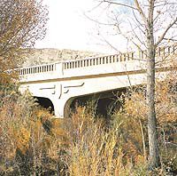
| The Muddy Creek bridge near the town of Emery. |
The Muddy Creek Bridge was built in 1940 during the last phase of paving State Road 10. It was a concrete, rigid-frame bridge ornamented with Art-Deco Thunderbird designs on the sides. Since early pioneer settlement times, bridges have been built to accommodate the crossing of Muddy Creek.
Before dams and reservoirs were built, the stream could become wild with run-off water. The first bridge was wooden and was replaced in 1910 with Carnegie-Steel-Truss Bridge. At that time, S.R.10 was gravel, dirt and clay. The new Muddy Creek bridge was constructed in 1940 and functioned well until 2005. It had to be replaced to accommodate the weight and traffic of coal haul trucks, important to the coal industry and economy of Emery County.
Like all of the towns in Emery County, the towns of Emery and Moore had to rely on streams carrying mountain water for irrigation and drinking. In the flat lands, where settlements had grown up, no springs or wells existed to provide the essential water. This precious resource had to be coaxed away from the major streams of the Wasatch Plateau watershed.
The Muddy Creek is the source of life and economy for the towns of Emery and Rochester (later named Moore). This southern part of Emery County was the last area to be settled in Utah. The Homestead Act of 1862 required 160 acres per claim. The first settlers in the Muddy Creek area established homesteads right along the Creek, which is located about five miles north of Emery. The pioneers first called their settlement “Muddy,” then “Casper,” after Casper Christensen, one of the first homesteaders and their spiritual leader “The Bishop of the Muddy.” A log school and a post office were built.
As more settlers were attracted to this new and last frontier, large tracts of homestead land became unavailable. Although more land lay to the south, there was no creek to water it.
Emery town: In the late 1870s, the settlers chose to move their homes to a location that could accommodate more people, houses, and businesses.
Water had to be taken from the Muddy Creek to the area designated for a town. The Muddy Canal Company was formed, and the settlers began digging a canal with their picks and shovels. The bed of the first diversion was made with layers of rocks. To save digging two miles of canal that would have to go around a large hill, the pioneers dug a tunnel through the hill, an incredible feat considering the available tools. They started from both ends of the hill and also dug from the top in the center of the hill.
As the digging neared completion, all points met. Modern engineers have marveled at this accomplishment. The pioneers’ tenacity and willingness to work hard made a difference in achieving their goal to build the town of Emery.
Rochester: About the same time the Muddy Canal was being dug, financial investors from the Eastern States became aware of the lush, productive farmland on the flats east of the Muddy River headwaters. The investors saw the potential and formed The Independent Canal Company to claim water from the Muddy Creek and coax this arid land into producing grain like in the Midwest.
Shares were offered to residents of the county, who also caught their vision. They began digging and blasting to build a new canal that would irrigate farmland and provide water. The new town was named Rochester after the hometown of one of the wealthy investors. The town had a store, brick school, and post office.
Later, when all of the Eastern investors had pulled out of the company, the name Rochester was changed to Moore to honor the postmaster who had purchased most of the land and managed it for so many years. Only a few residents still live in Moore. Most residents have moved into neighboring towns but have kept their farmland which continues to produce great crops.
| New sign tells history of old Muddy Creek bridge. |
These pioneer settlements of the late 1800s were also the crossroads for other historic civilizations. Fremont Culture “Emery County was an important center for the Fremont Culture which dates back to about A.D. 700 to 1000. . . The later Bull Creek phase (A.D. 1000 – 1200) seems to have developed during a wet cycle that allowed for more extensive agriculture and larger dwelling groups.” (Edward Geary, A History of Emery County.)
Rock art is found in several locations in this area, indicating historic civilization to the Muddy Creek area. The early inhabitants left notes on rocks about their lives in this area. Since no one seems able to interpret these writings with confidence, they are admired as inherited pieces of fine art. The National Geographic has called Utah “The Wilderness Louvre;” 226 rock art sites have been recorded in Emery County.
Utes: “What is now Emery County was part of the Ute domain. Accounts of early travelers indicate there were Utes in the area. The San Pitch band. . .probably made extensive use of western Emery County as they continued to do on a seasonal basis well into the settlement era. Early explorers found established trails. . .(in this area).” (Edward Geary, A History of Emery County, p21-22.)
The Spanish Trail: the main travel route through the Emery County region during 1570-1850 was the Spanish Trail. This trail made its way from Santa Fe, N.M., to California, crossing through much of Castle Valley.
Merchandise, such as fabrics and woolen goods, was traded in California for horses and mules. As many as 2,000 animals herded by 200 men on horseback would traverse this trail in about two and a half months.
One portion of the route is believed to be two miles north of Emery Town where it crossed the Muddy Creek.
Trappers such as William Wolfskil and George Yount, explorers John C. Fremont and Kit Carson, Mormon Battalion members, and gold-seeking 49ers made use of the trail. More clandestine users included bands of horse thieves and those trafficking in Native American slave trade exchange.
Emery County native Dan Price is 87 years old and now resides in Wellington. He was one of the original builders of the bridge over the Muddy River. He recalls working on the bridge in 1941. He was 20 years old and working for Thorn Construction.
He had just recently finished work with the CCC camps and found this job on the Muddy Creek bridge. He remembers the construction foreman being Les Evans and the superintendent on the job was Franz Bradley, whom they all called Boone.
He reflected on the hard time they had getting gravel for the project. There was a gravel hill near Emery which they used. They had dump trucks and would put a screen in the bottom of the truck to screen the gravel from the dirt. This gravel was used in the cement for the bridge.
Price said he received 50 cents an hour for driving one of these dump trucks. They put a hose in a ditch to get the water out to mix with the cement for the bridge asnd to wash the gravel. They used 1,600 bags of cement on the bridge alone, not the railings. They didn’t have the cement trucks like today and they mixed two bags of cement mix at a time in the old mixer.
All hands came together when it was cement pouring time, all the truck drivers and other equipment operators helped with the cement pouring. Price remembers other local men who helped with the project including: Mervin Peacock, Wilford Anderson, Christian Christiansen, Sid Sorensen, Stanford Johnson, Loren Minchey, Bryan Nielson, Burt Wilcox and Reed Keele to name a few.
Price said he thinks the old Muddy Creek bridge lasted longer than it probably should have with the materials they had available at that time in the 1940s.