Ray Petersen, Emery County Public Lands Director, informed the Public Lands Council of the recent release of the final resource management plan from the Bureau of Land Management. This plan was released on Aug. 29. There will be a final 30 day period of protest, which can only be made by those who have commented in previous phases, and will end Sept. 30.
“It is my opinion,” said Petersen, “that this plan turned out OK. There is a 6-7 percent decrease in the amount of lands available for oil and gas exploration. In the grazing area, the plan is pretty much unchanged from previous comment periods.”
Petersen noted the off highway vehicle designations for the northern portion of the area have designated routes finalized. More than 600 miles of open routes were added to the existing system through these designations.
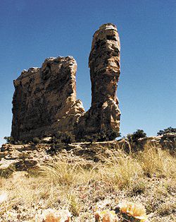
The new plan has chosen to keep 97,100 acres in the Hondoo Country, Mexican Mountain area, Muddy Creek/Crack Canyon, San Rafael Reef, and Wild Horse Mesa as protected areas with wilderness characteristics. The goal is to protect, preserve, and maintain the wilderness characteristics of these five areas. No oil or gas exploration will be allowed in these areas.
An ACEC is an area of critical environmental concern. The old proposal has eight of these ACECs and the final plan adds five more. The 13 areas, totaling 208,555 acres are: Big Flat Tops; Bowknot Bend; Dry Lake archaeological district; Interstate 70; Muddy Creek; San Rafael Canyon; San Rafael Reef; Segers Hole; Nine Mile Canyon; Cleveland/Lloyd Dinosaur Quarry; many heritage sites; the uranium mining district; and the rock art sites. Each of these ACECs are listed for different reasons, from historical value to visual value, along with other natural resource values.
Petersen noted one thing about the San Rafael River. It had previously been considered for the Wild and Scenic Rivers Act. In this final proposed plan, the San Rafael River will not be managed for wild and scenic. “From what I have seen and read so far, there is nothing to protest,” said Petersen.
Petersen also announced the proposal for Emery County to acquire the several hundred foot long tunnel in the MK tunnel complex, has been stopped. Following a letter written to the BLM from Emery County notifying them of their intention to acquire that land, the attorney for the BLM wrote back and said that under no circumstances would the BLM relinquish ownership and responsibility for that shaft. “As a result of this action, the BLM will probably install the bars across the opening and the mine shaft will only be a visual experience,” stated Petersen.
In other business conducted by the public lands council, Marc Stilson from the Division of Water Rights announced the state engineer’s meeting will be in Green River Sept. 24-25. On the trip to Green River from Salt Lake, the group will tour the irrigation systems in North Emery and Ferron. They will also tour several farms in Green River.
Councilman Sherrel Ward voiced his concerns about the watershed for Emery County that is in the mountains to the west of Emery County and located in Sanpete County. “I was concerned when Emery County changed from 80 acres to 40 acres for building. I don’t think Sanpete County has a restriction. I am very concerned for our watershed,” said Ward. The council agreed to write a letter to the Sanpete County Commissioners explaining the concerns.
Resource management plan from BLM is finally on the streets after years of work

"Certain areas will remain with wilderness characteristics in the new plan."
