At 5:48 a.m. on June 26, Emery County Sheriff’s Office Dispatch received a call advising that there was a fire at the south end of Candland Mountain and in the Forks of Huntington Creek. The caller advised that the fire could be seen best from the Miller’s Flat area. ECSO Dispatch forwarded all information to Moab Fire Center.
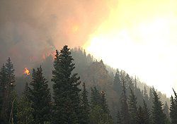
Moab Fire Center dispatched units to assess and fight the fire. Initial response by the Type 4 team included a helicopter with smoke jumpers. They were placed in by the fire by helicopter. The Incident Command Post was set up at the Rolfson Campground on June 26 by the Forest Service. The fire was identified as starting at these coordinates: N39*29.60 W111*10.40. The fire was in a heavily wooded area in the Left Fork. Early in the afternoon it went down the canyon to the Forks of Huntington on SR-31. The fire went north up Candland Mountain and toward Stuart Guard Station. It jumped SR-31 and went up into Nuck Woodward. The firefighters were able to save the structures at Stuart Guard Station. The fire spread northeast towards Castle Valley Ridge, Star Point and onto Gentry Mountain into Carbon County.
Emery County Sheriff’s Office, UHP and UDOT shut down SR-31 at Crandall Canyon Mine intersection which is MP 33, and also at the Emery/Sanpete County line at MP8 on SR-31. People were evacuated from the Scad Valley area, the top of Huntington Canyon and around Electric Lake. Evacuations continued with voluntary evacuation of residents in Trail Canyon. Rhino Mine is on alert and can evacuate within an hour if the fire threatens the mine property. People have been very cooperative when asked to evacuate.
It was learned that on June 25, citizens traveling through the Left Forks of Huntington Creek reported that they saw a lightning strike about 2:20 p.m. during a small thunderstorm.
Camp trailers have been removed from the area. The fire is still a threat to some cabins at the end of Candland Mountain and around Miller’s Flat. On Wednesday morning, the fire sent ashes down the canyon starting a small fire near the Huntington Power Plant, which was extinguished. The fire is still a threat to Huntington Power Plant and Deer Creek Mine. Numerous power transmission lines are also being threatened.
The fire is still burning on the ridges around Stuart Guard Station and into Carbon County with very little containment.
The Eastern Arizona Incident Management Team has been called in to manage the Seely fire in Huntington Canyon.
The total number of personnel fighting the fire is 463, including eight 20-person hand crews. The location of the fire is 15 miles northwest of Huntington. There are 20 engines onsite and eight helicopters. As of July 2 there were 20,175 acres involved. The fire is 10 percent contained and the cost to date is $1,816,566. There have been no human injuries in the fire. The historical Stuart Ranger guard station at the mouth of Nuck Woodward Canyon was protected from the flames. There are cabins near Cleveland Reservoir which are approximately two miles from the flames.
Incident Commander John Philbin’s Eastern Arizona Incident Management Team has taken over command of this fire, effective at 6 a.m. on June 29. Additional national resources have arrived with the Team, and more have been ordered. Extreme drought conditions, bark-beetle-killed trees, strong gusty and unpredictable winds are still driving the fire.
Full suppression strategy continues on all fronts of this fire, and structure protection measures continue to hold. Crews secured utility lines, gas lines and coal mining infrastructure within the fire perimeter.
SR-31 from Crandall Canyon Mine intersection to Miller’s Flat Junction is still closed, but SR-31 is now open from Miller’s Flat Junction to Fairview. The road from Miller’s Flat to Joe’s Valley is now open as well. SR-96 and SR-264 from SR-6 over to SR-31 and Mohrland Road to Gentry are still closed. Consumer’s Road is closed at the railroad crossing. The road to Wattis is closed. Tucker and Starvation Roads off SR-6 are closed. Also various Forest Roads within the fire area are still closed.
The Incident Command Post is located at the Canyon View Junior High School in Huntington. The fire is currently burning on lands administered by the Manti-LaSal National Forest Ferron-Price Ranger District, Bureau of Land Management Price District, State of Utah, and some private lands.
A Red Cross shelter has been opened at the LDS Stake Center in Wellington, Utah for food, shelter and mental health care needs of the evacuees. Contact 801-323-7000 for information on volunteering.
Emery County Sheriff Greg Funk said on Friday that flare-ups are occurring on Gentry and in the Left Fork area. Cattle have been spotted from the air and those appeared to be OK. It’s not known the status of all the cows on the mountain and there could be cattle deaths due to the fire. Most ranchers had not taken their cattle up to the mountain yet, due to the dry conditions causing lack of feed for the herds. Ranchers in the area have been instructed to remove their herds if possible.
The tanker planes are hitting the Hiawatha area to try to knock down the flare-ups.
Sunday’s Fire activity included: the line was held at Seeley Ridge on the southwest perimeter. Fire continued to burn in a big bowl at the top of Mill Canyon and increased in activity when thunderheads contributed significant downdrafts and spotted into Flood Canyon. In the early afternoon the fire in this area began to merge with fire burning north along Nuck Woodward Canyon and gained strength as winds associated with the overhead thunderheads increased. Activity in this area eventually contributed to spot fires and merged with significant increased activity along Lone Pine Tree ridge. The late afternoon fire’s largest column was located at Trough Springs Ridge. Firefighters held the line at a ridge northwest of Hiawatha and the fire did not get into Hiawatha. Firefighters were able to knock down the activity in Middle Fork Canyon and complete structure protection (including installing sprinklers in some areas) in Hiawatha, Clear Creek and Valentine. Price was heavily impacted by the large smoke plume blown east over town. Night shift crews continued structure protection for the evacuated towns of Hiawatha and Clear Creek.
Monday’s Weather will continue to be hot, dry and windy, with a probability of dry thunderstorms. Shifting wind patterns will carry fire in all directions, burning a lot of dry, dead, down timber, which will create large smoke columns beginning in the early afternoon.
Lightning strike causes Huntington canyon fire: zero percent containment to date
"Fire continues to burn in Huntington Canyon."