Seeley burned area still hazardous
Local officials are warning travelers that driving through the Huntington Canyon burned area can be perilous during and after rain storms.
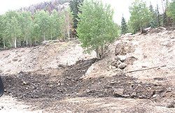
The Seeley Fire has left behind a landscape in Huntington Canyon unlike the one people have known for decades. Steep bare hillsides studded with black tree trunks have replaced thick stands of conifers. This landscape can be hazardous to the public.
Flash floods, falling trees, debris flows, blowing ash, smoldering logs and stump holes present a risk right now in the burned area.
Floods carrying tons of mud and tree trunks surged across SR-31 on July 7 and again on July 16, coming out of Nuck Woodward, Engineer Canyon, The Left Fork of Huntington, and Pole Canyon. These debris flows are deadly for anyone caught in their path. The flows can trap people on the highway between flows or at either end of the highway.
“People need to become aware of the weather and the changed environment,” said Capt. Kyle Ekker of the Emery County Sheriff’s Office. “There is more water, more sediment, and more debris. Don’t be there. Don’t drive through unless it’s absolutely necessary. It’s like the slot canyons in the San Rafael Swell. It may be dry where you are, but a storm miles upstream can bring a flash flood down in your area.”
Although SR-31 in Huntington Canyon is open from Huntington to Fairview, drivers are prohibited from stopping in the area below North Hughes Canyon. A Burned Area Emergency Response (BAER) team of natural resource specialists has been going into the Seeley Fire burned area the past few days to examine resource effects after the fire. A preliminary report of their findings is anticipated within the next week.
The Forest Service will base its decision about opening campgrounds and trails on the recommendations of the team.
“It might be a while before people are able to use their favorite campgrounds,” said Allen Rowley, Manti-La Sal National Forest Supervisor. “It may take one, two or three years for the area to stabilize so that it is safe for the public to use again.”
In the meantime, the Forest Service is asking the public to respect area closures. All National Forest System Lands within the burned area are closed to the public. This includes campgrounds, trails, the Nuck Woodward Road and Trough Springs Ridge Road. Open areas will be posted on the Manti-La Sal National Forest website (www.fs.usda.gov/mantilasal/) as they become available.