The Emery County Historical Society met at the Museum of the San Rafael in Castle Dale.
Susan Anderson introduced the guest speakers Steven Heath the Utah Director of the Old Spanish Trail Association and Dottie Grimes formerly the director of the Emery County Archives Department.
Heath is a retired Southern Utah University math teacher. He has a Masters Degree in history. He and his wife Donna came to Emery County to explore part of the Old Spanish Trail and to help with the organization of an Emery County Chapter of the Old Spanish Trail Association. He was asked by the Historical Society President Evelyn Huntsman to present a program about the Old Spanish Trail. He has done extensive research about the Old Spanish Trail.
Heath said, the mission of the Old Spanish Trail Association is to study, preserve, protect, educate and promote respectful use of the Old Spanish National Historic Trail and closely related historic routes. The Old Spanish Trail crosses through six states. These states are New Mexico, Arizona, Colorado, Utah, Nevada and California.
He described the steps required to organize a Chapter for the Old Spanish Trail Association as follows: 1. Draft a set of by laws. A copy of the Mojave River Chapter By Laws was left as an example. 2. The chapter needs a minimum of 10 members. Heath had membership applications available. 3. Next officers are to be elected. 4. Give the chapter an official name. The group selected the name of The San Rafael Chapter. He gave examples of other names being used. In Kanab their chapter is the Red Pueblo Chapter. The St. George chapter is the Trace (three) Trails Chapter. 5. The chapter needs to get an EIN tax ID Number before becoming an official chapter. Membership dues are $30 for a family and $25 for an individual. This money goes to the national organization first and then part of the money is returned to the chapter.
The chapter organizes field trips, puts up Interpretive Signs that identify the trail and puts information with maps at kiosks located near the trail.
Heath said, With a membership you will get a magazine titled “Spanish Traces” published three times a year. A recent issue has Bernice Payne’s map of the old Spanish Trail including the GPS locations of watering holes along the trail.
Heath suggested that field trips are helpful to members as they get to see the terrain over which these traders traveled such as the Wonder Valley in Nevada and the Hurricane Cliffs in southwest Utah. These cliffs are red, limestone cliffs and only two or three places in the Hurricane fault allow the Mexican traders to get off of or over the 1,000 foot tall Hurricane Cliffs. One of those places is called the Huntington Trail.
In 1829 the trader Antonio Armijo took a caravan on a round trip with about 100 pack animals from Abiquiu, New Mexico to Los Angeles, Calif. along the Utah and Arizona border crossing over the Hurricane Cliffs and through Wonder Valley. Other traders used the longer Northern route through Emery County.
The Old Spanish Trail is a National Historic Trail. In the U.S. there are 19 National Historic Trails. Such as the Lewis and Clark Trail, The Oregon Trail, The Mormon Trail, The Pony Express Trail and The Freedom Trail from Selma to Montgomery to name a few.
Heath presented the Historical Society with several large colorful maps of the Old Spanish Trail showing the routes used and said the Old Spanish Trail is really a continuation of the trail from Independence Missouri to Santa Fe New Mexico then on to Monterrey California.
The water holes were a very important resource for the traders and their animals. If you know where the water was available, you can easily determine about where the Old Spanish Trail went.
Before 1829 the Spanish people had started to move into the California coast and to explore and it became important to establish trade routes into California.
Fathers Francisco Atanasio Dominguez and Silvestre Velez de Escalante searched for an overland route through the Ute Indian land to an established settlement at Monterrey. They were to open up a trade route, find places to convert Indians, discover resources and communities that could be established in 1776. There had been earlier Spanish expeditions into this part of the country (meaning Emery County).
A lot of things changed in 1821, when Mexico declared Independence from Spain.
Heath said, The book in search of the old Spanish Trail is actually a misnomer. It should have been in search of the old Mexican Trail. Because it was Mexicans that established the trail. The trail was first established in 1829, by a Mexican by the name of Antonio Armijo who chose a direct route from Santa Fe to Los Angeles. He went a little bit north and followed the 37th parallel. That is the border of Utah and Arizona. In 1829, there was only the barest trace of a trail through some of the most difficult terrain you could find. Escalante found a piece of that trail when they crossed the Colorado River. Armijo was packing serapes to California along with possibly some pots and pans or domestic goods. California didn’t have any of those things.
There was no wool industry in California or anything like that in 1829. The Californians did however have horses to trade for the Mexican goods. Horses were badly needed in New Mexico and along the Spanish Trail by the Indians and the intersecting trails out of California. It is believed that these traders made a lot of money. The trade items were horses and slaves made up of Indian boys and girls.
If you have driven from Four Corners to Mesquite, Nev. You know how difficult that terrain is. This southern route was not a good choice due to the Apaches and the lack of water.
So the traders came north among the Utes, Paiutes and others. This route was a little longer. However it was a very well watered route and there were places to feed 60 or more mules.
By 1831, there were caravans traveling from Santa Fe to California and returning. Primarily, it was the horse, dry goods trade and Indian slave trade. On the western side of Utah, the Paiute Indians were reduced to four adult males to every adult female because of the Indian slave trade.
It is estimated that 7-10 year old Indian girls could be sold for $500 in gold in Santa Fe or Los Angeles as a domestic servant, a young Indian boy would bring only $100.
The U.S. Congress said the old Spanish Trail was from 1829 to 1840, and they designated three basic trails. The northern route to Grand Junction, Colo. then to Green River following I 70 where it joins another northern route, which came out of Abiquiu and Santa Fe. This trail follows up through Moab to Green River and around the top of the San Rafael Swell. The Spanish Trail goes a little bit west of St. George. At Las Vegas, there are couple of branches of the trail.
Heath emphasized there are two key things needed along the trail, and these key things are water and feed for the animals.
From Mesquite, Nev. to Los Angeles there is a large hot dry desert, and the last big feeding place was Mountain Meadows in Utah. The reason there is more than one trail is because other traders ahead of you may have used up the available feed in a particular place. Essentially The Old Spanish Trail went from waterhole to waterhole.
The timing for traveling the Old Spanish Trail had to be quite precise. You had to leave Santa Fe, New Mexico in the spring or in March. You then traveled north around the San Rafael Swell. There are two places that you can’t get across if you wait to go much later in the year. These two places are the Colorado River and the Green River due to spring flooding. If you go much earlier in the year you also have to contend with the snow when crossing the mountains. There is usually plenty of water in the spring of the year. But that is not always true in the fall of the year.
The heat across the desert is a tremendous problem and you don’t want to be on the desert after May 15. A well-timed expedition is important. There’s a lot of money invested in these expeditions. Just like any business venture today. The investors are expecting a return on their money. Then in September you start back again, not too soon because you don’t want to be in the desert during the hot part of the year. You have to be across the mountains in early winter. Returning from California to New Mexico finding water is a little more difficult. Thompson Springs in Sacco Canyon is a key place to stop west of Green River.
There are three reasons why the trail stopped in 1848, and they are the Mexican war in 1841 and the Mormons coming to Utah, they didn’t like slavery. They actually fought a war in 1853, called the Walker war because of the slave trade. The third reason for trade along the Old Spanish Trail disappearing is the California gold rush.
Chief Walker had a favorite place down in Iron County. A little narrow canyon called little creek. Chief Walker had a good business in that canyon. He was considered to be a wealthy Indian. Walker would set up camp at the entrance of that canyon and ask for payment from anyone wanting to pass through the canyon. The traders would usually give him a couple of horses as payment. Walker was interested in selling slaves. The Ute’s were stealing Paiute Indian women and children to sell and trade.
A lot of this information comes from journals made from 1848 to 1858.
Finally a Colorado legislator introduced a bill in Congress to recognize the Old Spanish Trail and the Old Spanish Trail was recognized as the fifteenth National Historic Trail in December of 2002. This trail can become an asset to your community.
Dottie Grimes then with the help of Vernell Rowley identified a number of trail intersections and their GPS coordinates on a map she supplied.
Historical society learns about the Old Spanish Trail
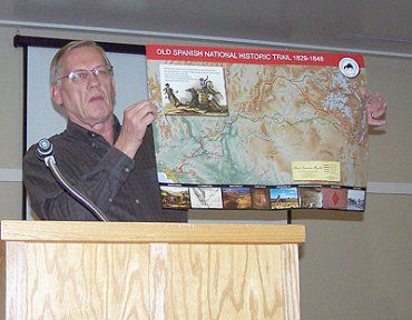
"Steven Heath teaches about the old Spanish Trail."