The Bureau of Land Management Price Field Office hosted two public scoping meetings for the San Rafael Desert Travel Management and Transportation Plan. The Environmental Assessment comment period will run Jan. 21 to Feb. 21. The purpose of public scoping is to determine relevant issues that will guide the planning process and influence the scope of the environmental analysis, including development of alternatives. As a result of the travel management planning process, each route on lands managed by the Price Field Office will receive a designation of “open,” “closed,” or “limited to designated routes.” The travel management plan will be subdivided into five areas with a separate EA and 30-day public scoping period for each area. The first area to be analyzed is the San Rafael Desert area, which includes the San Rafael Desert south of I-70 and east of Hwy 24 to the Green River and Emery County line. Total acreage is for all lands found within the travel management zones.
The total acres within the San Rafael Desert area is 439,734. The other areas to be included in the travel management and transportation include Carbon, Chimney Rock, West Emery and the San Rafael Swell. Each area will be examined and the process completed before moving onto the next area. Total acres for Carbon are 949,686, Chimney Rock total acres 735,962. San Rafael Swell, total acres, 753,665 acres; West Emery is the next area that will be assessed after the San Rafael Desert is complete. West Emery total acres is 923,757.
BLM Recreation Technician, Jaydon Mead said there are two main things they are looking for in the public comment period. The inventoried routes are on the map and the BLM wants to know if they are missing any significant routes, roads or trails. Each route will be examined to determine the purpose and need of each route. Are the routes used to get to a cattle watering hole, do they lead to hunting or camping spots? Do they lead to a scenic overlook or other destination? Are they access points to hiking or biking trails? Is a road part of a loop system to get to another road? Is there any other environmental, or resource issues? These are the questions that need to be addressed concerning each route. This scoping period is open for input on things of significance that the public would like us to consdier as well. For example how would these road systems impact any sensitive species found in the area. These are also comments we would like to hear from the public. Now is the time to put your input into the process. After all the public comments are gathered and the BLM staff has completed route evaluations, then the process of developing alternatives for the EA will begin. One alternative could be no action, leave as is; one alternative could be more prone to opening more routes; another alternative could be more strict or less access; and another alternative could be developed with a more moderate balance of open trails and routes.
In 2008, some routes were designated in the transportation plan, but now the BLM is coming back and taking a more comprehensive look at the transportation routes within the Price Field Office BLM lands. Comments can be emailed or mailed to the BLM. Generic comments are OK, but specific comments addressing specific routes are better and have more purpose and meaning.
At the Green River open house there were approximately 40 people who attended and gave comments. The Castle Dale open house received several comments as well.
Mead said an inventory was done by ARS contractors, but some routes or linier feature may have been missed. The comments will be evaluated by an internal team from the Price Field Office. The team will include range specialists, soil specialists, wildlife specialists, burro and wild horse specialists, recreation specialists and others. They will all sit down and evaluate each route for its purpose and need, and identify other resource issues that may be present. Another part of the evaluation will include whether that route will be open to all uses, or specific; for example only ATV, only bikes, hiking, or equestrian, single track motorcycle, etc. Some routes will have more than one use; others may be exclusive to one use. Some roads are considered primitive, some jeep trails and some are suitable for passenger cars. There are many different routes and trails with varying uses. The main routes are maintained by the county. Mead said there is also a possibility of having sections of open areas where cross country travel could occur in play areas. This designation might be suitable for highly roaded areas with a lot of different roads and trails and also sandy areas. After the alternatives are developed then they will come up for public comments again. These additional comments will be taken into consideration and then the final decision for which alternative will be selected will be made by the Price Field Office Manager, Ahmed Mohsen.
Each of the five areas will go through the same Environmental Analysis process. Phase II will start after Phase I is complete. It’s projected each study area could take a year or longer and the whole area could be completed in five years possibly longer. BLM personnel stressed the importance of being part of the process and getting your comments in to be considered. Josh Winkler is an Outdoor Recreation Planner for the BLM. He said the areas have been split into five distinct areas because they are more manageable pieces. Tackling one area at a time will lead to a more thorough evaluation process of the transportation system on the BLM lands.
The public is encouraged to view a map of the planning area and current route inventory maps on the Environmental Notification Bulletin Board at: https://www.blm.gov/ut/enbb/index.php (search for project name “San Rafael Desert”). Written comments will be accepted throughout the scoping period which ends Feb. 21. Reference “San Rafael Desert Travel Management” when submitting comments. Comments may be mailed or emailed using the following:
Mail: BLM Price Field Office
125 South 600 East
Price, UT 84501
*Email BLM_UT_PR_Recreation@blm.gov.
BLM hosts public comment meeting on routes
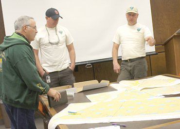
"Public lands council member Rod Player looks over the maps with BLM employees Matt Blocker and Josh Winkler. They are outdoor recreation planners."