After three years of work a draft document of the Public Lands Initiative was unveiled by Rep. Rob Bishop and Rep. Jason Chaffetz on Wednesday.
Emery County public lands director Ray Petersen said, “We’re encouraged to be at this stage, finally. We haven’t fully evaluated the discussion draft, but there is much we have read that is encouraging. We’ll be scrutinizing both the language and the maps. Stakeholders are asked to submit proposals as to how to address the Antiquities Act issue.”
Commissioner Keith Brady said, “It’s been a long road to get to this point where there is legislation to go before Congress. Reps. Bishop and Chaffetz have been working with various interest groups to make sure everyone has input in the process. Not everyone is getting all that they want, there had to be compromises on both sides. I am cautiously optimistic for this bill. With what Reps. Bishop and Chaffetz want with this bill, and if it passes through Congress and the President signs it, it will give the businesses and people of Emery County certainty regarding all usages of the land, e.g. mineral extraction, grazing, recreation, etc.”
The PLI will create 41 wilderness areas covering 2,274,373 acres of federal land. Wilderness is the most restrictive federal land designation and ensures that rugged landscapes will remain intact for future generations to enjoy. PLI will more than quadruple the number of acres of wilderness designated within the counties. The PLI Region covers seven eastern Utah counties, Emery, Carbon, Grand, San Juan, Duchesne, Summit, Uintah and Duchesne encompassing approximately 18 million acres of federal land. Members of the Utah Congressional Delegation, local officials, and stakeholders have met over 1,200 times in an effort to craft a comprehensive land-use plan for the entire region.
The following areas of Emery County are designated as wilderness and as components of the National Wilderness Preservation System: Candland Mountain. managed by the United States Forest Service comprising approximately 12,330 acres. Desolation Canyon in Duchesne, Uintah, Carbon, Emery, and Grand counties comprising 473,272 acres, which shall be known as the “Desolation Canyon Wilderness.”
Mexican Mountain-85,150 acres; Sids Mountain-82,406 acres; Muddy Creek-72,400 acres; San Rafael Reef-65,146 acres; Crack Canyon Wilderness-27,191 acres; Devils Canyon 8,652 acres; Nelson Mountain-comprising approximately 12,856 acres; Labrynth Canyon-52,969 acres; Cedar Mountain-17,355 acres.
Proposed National Conservation areas include: San Rafael Swell-329,933; Labrynth Canyon. 35,049 acres administered by the Bureau of Land Management in Emery County and Grand County. Muddy Creek-55,208 acres. Advisory councils will be set up to oversee the National Conservation Areas.
The PLI also contains the creation of the Jurassic National Monument at the current Cleveland-LLoyd Dinosaur Quarry. The purpose of this monument is to conserve, protect, interpret, and enhance for the benefit of present and future generations the unique and nationally important paleontological, scientific, educational, and recreational resources,the Monument shall consist of approximately 867 acres. An advisory council for the monument shall be created to guide the activities at the monument.
Within the PLI is the creation of segments of wild and scenic rivers including: Green River-the approximately 50 mile river segment from River Mile 97 at the confluence with the San Rafael River to Canyonlands National Park Boundary as a scenic river. The approximately 44.5 miles from Nine Mile Creek to Chandler Canyon as a wild river; The approximately 8 miles from Chandler Creek to Florence Creek as a scenic river. The approximately 19 miles from Florence Creek to the Nefertiti Boat Ramp as a wild river. The approximately 62 miles from the northern border of the Desolation Canyon Wilderness, in Uintah County, to the Carbon County line as a scenic river.
The PLI contains a request from the state of Utah that approximately 9,994 acres of Bureau of Land Management land be used to expand Goblin Valley State Park. This expansion will operate under a cooperative agreement in accordance with the San Rafael Swell National Conservation Area and the Crack Canyon Wilderness Area as established in the PLI.
Other land conveyances include to Emery County-Huntington Airport Expansion-this includes approximately 1,398 acres for expansion of the Huntington Municipal Airport.
Emery County Recreation area includes approximately 479 acres for public recreational purposes.
Emery County Sheriff’s substation includes approximately 643 acres for a substation for the Emery County Sheriff’s Office.
Range Creek Research Station Expansion approximately 1,663 acres to the University of Utah for education and research.
Emery Information Center at Buckhorn Draw 80 acres for an information and visitor center to promote public lands.
In the section of the PLI entitled long term travel management certainty, the bill asks for right of ways on certain roads. Bill language says, “Subject to valid existing rights and consistent with this section, the Secretary of the Interior shall grant a right of way to the state for public travel and access upon the following roads:(1) all roads claimed as Class B identified as rights of way in judicial actions in the federal court system as of January 1, 2016 in Uintah, Summit, Duchesne, Carbon, Emery, Grand, and San Juan counties. (2) all roads claimed as Class D highways identified as rights of way in judicial actions in the federal court system as of January 1, 2016, in Uintah, Summit, Duchesne, Carbon, Emery, Grand, and San Juan counties, as long as the claimed Class D highway does not pass through United States Forest Service or National Forest System lands, Bureau of Land Management lands designated by Congress as wilderness, excluding those roads which are cherry stemmed, including lands designated as wilderness or National Conservation Area under this Act, or lands designated by Congress as a National Park as of the date of enactment of this Act. Applicable law. A right of way granted under subsection (a) shall be granted in perpetuity, except in the case of abandonment, and shall not require the payment of rental.”
Southern Utah Wilderness Alliance, Grand Canyon Trust, The Wilderness Society, Natural Resources Defense Council and the Sierra Club issued a joint statement on the PLI. “The proposed legislation released by Representatives Rob Bishop and Jason Chaffetz does not protect the world-renowned redrock scenery of the national public lands in Utah, including the spectacular Bears Ears cultural landscape, and instead imposes unprecedented and controversial proposals that would adversely affect wildlife, recreation, and watersheds in key areas across eastern Utah.
“The draft PLI is an un-wilderness bill,” explained Scott Groene, executive director of the Southern Utah Wilderness Alliance. “Effectively, less wilderness would be protected in Utah if this bill passed than what is currently managed for the public. The wilderness it designates includes unprecedented loopholes and caveats, like enshrining grazing. This proposal does not do justice to these world-class landscapes.”
“The draft PLI weakens existing protections for important natural and cultural resources inside the proposed Bears Ears National Monument,” said Bill Hedden of the Grand Canyon Trust.
“We are disappointed that after years of good faith effort to identify common ground with counties, conservation organizations, tribes, and others, the proposed bill neither honors important agreements that were forged during the PLI process nor offers a reasonable path forward on many issues of critical importance,” remarked The Wilderness Society’s Paul Spitler. “The draft PLI includes many controversial proposals that lack support and would damage scenic public lands in Utah.”
“This is really a fossil fuels bill,” observed Sharon Buccino, director of the land and wildlife program at the Natural Resources Defense Council. “It opens up areas managed as wilderness for coal mining, tar sands, oil shale, and oil and gas and dedicates millions of acres to energy development.”
The National Parks Conservation Association has been a stakeholder in this process since its beginning, encouraging an open, transparent process for determining land designations. NPCA’s goal for this legislation is to protect and conserve the unique ecological value of the larger shared landscape, while allowing for a variety of recreational opportunities, appropriate development, and a robust local and state economy. NPCA finds that this current draft does not meet those objectives.”
After the release of the PLI there were some groups which spoke in support: “After working with Congressmen Bishop and Chaffetz and a broad range of Utah stakeholders we are proud to be part of this important milestone,” said Kathleen Sgamma, vice president of government and public affairs at Western Energy Alliance “Balancing conservation and multiple-uses on public lands in Utah is important. For decades, certain groups and politicians from outside Utah had been pushing for a top-down bill to lock away millions of acres of public lands, whether or not those lands were supporting the economic viability of local communities or actually required special conservation. By engaging in a bottom-up approach with those directly affected as well as a broad range of stakeholders, Congressmen Bishop and Chaffetz have shown that collaboration and compromise can work, even on very contentious public lands issues.
“We are disappointed that the draft, which designates 4.3 million acres for conservation only, does not include a provision to require congressional consent for any Antiquities Act designation in Utah, as Wyoming enjoys. With such a large area designated for conservation, it seems that such a provision is in order,” concluded Sgamma.
Comments and discuss ion about the bill will take place until about the end of February, when it will be introduced in the House according to Rep. Bishop.
A website www.UtahPLI.com has been set-up where you can view the entire draft and the maps. This website will include a section where the public can comment and give their thoughts and opinions on the draft bill.
Draft language for public lands initiative ready for feedback
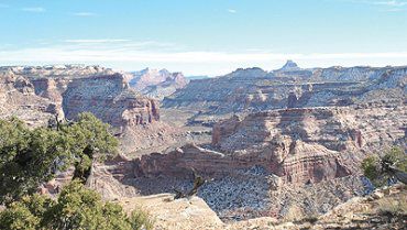
"The Wedge would become part of the San Rafael Swell Conservation Area if the public lands initiative passes Congress."