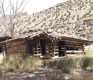
| A management plan will soon be in place for Range Creek. |
Derris Jones of the Division of Wildlife Resources reported to the Emery County Public Lands Council that the Range Creek management plan is being written and will be ready soon. He also stated that as far as wildlife is concerned, the Salt Lake group has given the ultimatum for the DWR to manage the wildlife in the state to objectives. This will cause an increase in the number of bull elk permits on public lands to be recommended. He estimated the number of elk permits on the Manti will raise to 345.
The Council recommended a replacement on the council for wildlife chair Eric Luke who resigned. Following advertisement for the position, two letters of application were received. The council reviewed the applications and voted to name Mark H Williams as their recommendation to the commissioners. The appointment will be made at the next commission meeting.
Commissioner Drew Sitterud reported to the council that little has changed with the RS-2477 issue. Although the bill passed defining the measurements of the roads and trails to be taken from the center line. This bill will allow the county to move forward with setting up a template for this recording. Commissioner Sitterud requested a group made up of members of this board to help with setting up that template.
The goal at present is to get as many of the roads recorded as possible. In this beginning phase, all of the roads that are not in contention will be recorded, and the records will be kept electronically in the county recorders office. Each road that is recorded must have been in continual use since 1967.
Members of the council questioned Commissioner Sitterud about the ruling of RS-2477 stating the year 1976. Commissioner Sitterud informed them that the most recent ruling said that a road must have been in use for 10 years prior to FLPMA in 1976. They have filed an appeal, but as yet have no answer, so they must work on the latest ruling guidelines.
“This is the first time we have been able to record any roads so this will be interesting to see what works out,” said Commissioner Sitterud. “We are going to go until we are appealed and then we will have to stop at that point.”
A discussion followed concerning the forest service roads. Most of the roads being considered in the RS-2477 issue are on the Bureau of Land Management lands. Each county makes recommendations to the forest service about the roads and to this point the forest service has taken the recommendations.
In the access portion of the council meeting, Ray Petersen announced the new BLM route designation maps will be out soon. The maps are at the printer now and everyone is hoping for distribution to begin before April 1.
| Rock art is abundant in Range Creek. |
Petersen announced a meeting for public comments concerning the Factory Butte area. This meeting will be held at the courthouse in Loa on March 24 from 8 a.m.-2 p.m. “This area has become a focus point of motorized access recently,” said Petersen.
Council member Priscilla Burton reported about the split estate issue. This means that a portion of land is owned by a party, who is considered the surface owner. The mineral rights may be held by another individual or entity. Sometimes issues are raised where the surface owner and the mineral rights owners can be at odds over rights. The surface owner generally has no say about what means are taken by the mineral rights owner to access or extract the minerals.
During the forest service report, Chairman Bruce Wilson reported that he is heading up a group of dedicated hunters who are going to install cattle guards on several of the roads and trails. The first one will be in the Rock Canyon area and several others will soon follow. “This will be an ongoing project by the dedicated hunters, so if anyone knows of an area where a cattle guard is needed, please let us know,” said Wilson.
During the heritage report, Mike McCandless reported that the process has begun to join the Old Spanish Trail Association. The paper work is being completed to form an Emery County chapter. “There will be a scoping meeting at the John Wesley Powell River History Museum in Green River on April 19 at 5:30 p.m. It is very important that everyone attends and comments about the future of the Spanish Trail. This meeting is to take public comments about what to do with these routes,” said McCandless.
Sherrel Ward reported about the water conditions in Emery County. “Prior to these last two storms, we were looking at a March just like the one two years ago. We were way below average. Following these storms, every drainage is above the 100 percent mark. Things are looking good,” said Ward.
Concerning the salinity project, Ward reported the attorneys for the Huntington Cleveland Irrigation Company and the Bureau of Reclamation have each studied the issue and agreed that the project did not require a bid process. This allowed HCIC to negotiate with Nielson Construction for the completion of the project. Construction will begin in the spring.
Wayne Luddington of the BLM stated that a large contingent of volunteers is coming into the Swell to work on signage of the roads and trails to be in compliance with the new route designation plan. Volunteers are coming from Emery and Carbon counties as well as from the Wasatch Front. These volunteers are OHV groups and dedicated hunters. Sometime during the first part of April, a large group will come from Grand Junction, Colo. to work on the east side of the Swell.
Petersen made the proposal for the Public Lands Council to take a field trip into Range Creek. He has filled out the necessary application for admittance and is proposing to take the trip in June. The council approved the date of June 16 for the trip.
The next Emery County Public Lands Council will be April 11 at 10 a.m. in the county building.