The Seeley Fire is in the wind down phase. A meeting was held at Canyon View Junior High to brief agencies and the county on what to expect in the aftermath of the fire. Forest ranger from the Ferron office, Darren Olsen said they are continuing to work on the fire and work on hot spots will go on throughout the summer. There will continue to be smoke and heat from the fire in the upcoming weeks. Workers will monitor these spots and continue to watch so they don’t grow.
The BAER team will come in to assess the fire. This is the Burned Area Emergency Response team. They will look at the needs for the fire including erosion control, seeding problem areas including the fire lines and will monitor the regrowth of the natural vegetation. They will look at what can be done to mitigate the damage. They won’t be successful in stopping all erosion, but they will identify troubled areas and that is the main focus of that team. This BAER work will continue for the next couple of weeks. These experts will move around the burn area and look at the resources and make recommendations as to what can be done and they will come up with a proposal. Because of the number of fires this season, the resources and money pool will be greatly stretched and a shortage in that pocket of funds may determine the extent to what rehabilitation measures can be taken. Olsen said, “We will do the best we can with the money we have.”
Areas greatly affected by the fire include the stockmen and grazers and recreation. The burned forest presents a variety of dangers to the public including rock and timber slides and flash flooding. Camping is closed in the burn area. All trails are closed at this time to give the forest service time to check for debris and downed trees on trails. They will begin to do the work that needs to be done so at some point trails can be reopened. Snag trees will need to be eliminated. “There’s a lot of work that will need to be done. Work for years to come to return this area to the scenic byway it has always been; so we can enjoy the mountains like we have been able to up to this point,” said Olsen.
Tom Boheena, the operation section chief said the Arizona management team has been in charge of the fire for the last couple of weeks and July 12 was their last day. He showed the map and felt like it was the final perimeter of the fire. He feels the fire is under control unless some unusual weather patterns develop. The fire has been divided into sections and different groups of fire fighters assigned to each section. The fire put itself out in some areas where it ran out of fuel, especially near the cliffs around Hiawatha and other areas with similar terrain. Vick’s Canyon continues to burn and smolder. There are a few flare-ups here and there within the fire perimeter. Crews were still working in Cox Canyon on July 10. Firemen will continue to patrol the burn areas to watch for trouble spots. The sprinkler set-ups have been pulled from the Hiawatha area. There is still a coal pile burning in Hiawatha.
Concerns about the mudslides between South Hughes and Engineer Canyon are just part of what’s to come. Any amount of rainfall can start the debris coming down the now bare hills, when it reaches the flat surface of the highway it spreads out over the flat area and causes problems. The sheriff’s office and Utah Department of Transportation will be on the alert for any road blockages and they will be dealt with as they come.
Sandee Dingman pointed out one danger the flash floods can cause the roads to wash out underneath the pavement and the road can cave in and culverts are easily plugged with timbers. She cautioned drivers of the canyon to be extremely careful and to stay out of the mountains if it looks like rain. Black water has been flowing in the Huntington Creek and the Price River.
Kelly Allen told about the remote weather detection devices which are being set-up at key spots around the burn area which will alert officials to any signs of changes in the weather so alerts can be issued and action taken. These portable weather stations have their own power supply. They give real time information on wind speed, rain and weather conditions. A list is being compiled of who to notify when weather conditions change which may affect the stake holders. Those putting out the monitors discovered they aren’t elk proof, as curious elk in the area nosed around the monitors. The monitors can set off alarms in various locations to alert of the weather changes. Once these alerts are received the public can be notified with the reverse 911 system. Costs associated with the weather monitors are minimal.
The BAER program is a federal program whose purpose is to protect life, property and natural resources. They will initiate emergency stabilization of burned areas to help with watersheds. Watersheds involved in the burn area include Huntington, Miller Creek, Pinnacle Wash, Gordon Creek and Mud Creek. Huntington Creek is the largest area involved in the burn area. Most of the other watersheds are out of the burned area. Post fire flash flooding is a real danger to the public. The BAER team does not replant or log out areas. They do emergency watershed stabilization. They will bring in geologists, hydrologists, GIS personnel and they will consult with the local entities and will prepare a satellite image map of the area which will also show unburned areas. These models will help predict what rain falls are likely to do. BAER will identify threats and mitigate risk and offer solutions and treatments. It will take one year to implement and three years of monitoring. The evaluation process will take at least two weeks and any treatment plans are subject to approval. It takes money for implementation.
The early warning systems will alert personnel to see if emergency closures of the roads are necessary during weather events. BAER work will also include increasing the road drainage capacity sometimes by increasing the size of culverts. Some changes of road design is sometimes necessary. They will work to remove floatable woody debris from areas. They will work to stabilize hillsides where feasible. A lot of road work will be done to keep travel ways safe. They will seed where feasible. There will be areas where steep terrain presents problems for rehabilitation work. A lot of treatments will be considered. Work cannot be done over the entire 50,000 acres. Rehabilitation work is costly often three times the amount of the cost of the fire. Work will begin first with the main objective being the protection of life and property.
Jason Roper from the NRCS said they are available to help with rehabilitation on private lands. A county or a city must sponsor land to be rehabilitated and they have a cost share program 75/25 and in-kind work can count as match money. Private lands comprised 6,000 acres in the Seeley fire.
The BAER team will reseed under limited conditions, mainly dozer lines and water shed related projects. We would like to get it growing before a significant rain event. Seeding for erosion control is limited. Long term rehabilitation for the burned area is under a different program.
Capt. Kyle Ekker thanked the Arizona team for all the work they have done.
Fire meeting discusses what lies ahead for burn areas of Seeley fire
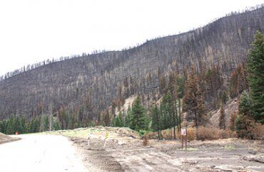
"Bare hill sides left behind make the burn area prone to slides and flash flooding."